Central Shenandoah Hazard Mitigation Plan
Click to view the main document, excluding the appendices.
 Central Shenandoah Hazard Mitigation Plan
The Central Shenandoah Hazard Mitigation Plan is a regional plan to protect our communities from natural disasters and other threats before they strike. Developed through a partnership of 5 counties, 5 cities, 11 towns, and 4 special districts, this plan identifies the hazards facing our region—including flooding, drought, wildfires, extreme temperatures, and critical infrastructure failures—and outlines actions to reduce their impact.
Once approved by the Virginia Department of Emergency Management (VDEM) and the Federal Emergency Management Agency (FEMA), projects identified in this plan will become eligible for federal grant funding.
What This Plan Does
Developed under the Disaster Mitigation Act of 2000, this plan empowers community leaders to:
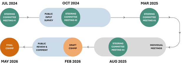
The CSPDC launched the planning process in July 2024, and over the two years that followed, the project was shaped by four steering committee meetings, individual consultations with each participating locality, and public surveys that drew input from more than 450 residents.
On May 20, 2026, FEMA officially approved the updated Central Shenandoah Hazard Mitigation Plan. Additionally, the plan met an optional requirement—the High Hazard Potential Dam (HHPD) requirement—which unlocks an additional funding category specifically for addressing dam failure risk.
Timeline item 1 - complete
Draft Plan
Feb 2026: The CSPDC completes the draft plan and distributes it to stakeholders for formal review.
Timeline item 2 - complete
Review by VDEM
Mar - Apr 2026: VDEM will review the plan and provide feedback. Once revised and approved, the plan is forwarded to FEMA.
Timeline item 3 - complete
Review by FEMA
May 2026: FEMA has 45 days to review the draft plan, after which they will request additional edits or approve it pending local adoption.
Timeline item 4 - active
Local Adoption of the Plan
Jun 2026 - May 2027: All 25 participating entities (Counties, Cities, Towns, Special Districts) may formally adopt the Plan. Adoption maintains participants' eligibility for mitigation grant opportunities.
Click to view the main document, excluding the appendices.
Originally adopted in 2005, this plan represents the third comprehensive update and reflects nearly two years of collaborative work. The planning process included four steering committee meetings, public surveys that gathered input from over 450 residents, and individual consultations with each participating locality. This community-driven approach ensured that local knowledge and diverse perspectives shaped our strategies.
The result is a roadmap tailored to our region's unique characteristics—from mountainous terrain and karst topography to National Radio Quiet Zone regulations—that will help us build a safer, more prepared region for generations to come.
Use the following drop-down menus to access individual chapters and plan appendices.
Bath-Highland Subarea Action Tables
Staunton-Augusta-Waynesboro Subarea Action Tables
Harrisonburg-Rockingham Subarea Action Tables
Lexington-Rockbridge-Buena Vista Subarea Action Tables